Daggett, Michigan | |
|---|---|
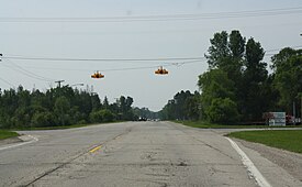
 Downtown Daggett along U.S. Route 41 | |
 Location within Menominee County and the state of Michigan | |
| Coordinates: 45°27′47″N 87°36′10″W / 45.46306°N 87.60278°W | |
| Country | United States |
| State | Michigan |
| County | Menominee |
| Township | Daggett |
| Area | |
| • Total | 1.12 sq mi (2.90 km2) |
| • Land | 1.12 sq mi (2.90 km2) |
| • Water | 0.00 sq mi (0.00 km2) |
| Elevation | 705 ft (215 m) |
| Population | |
| • Total | 201 |
| • Density | 179.30/sq mi (69.23/km2) |
| Time zone | UTC-6 (Central (CST)) |
| • Summer (DST) | UTC-5 (CDT) |
| ZIP Code | 49821 |
| Area code | 906 |
| FIPS code | 26-19560[3] |
| GNIS feature ID | 0624271[4] |
Daggett is a village in Menominee County of the U.S. state of Michigan. The population was 201 at the 2020 census,[2] down from 258 in 2010. The village is located within Daggett Township and is part of the Marinette, WI–MI Micropolitan Statistical Area.
- ^ "2022 U.S. Gazetteer Files: Michigan". United States Census Bureau. Retrieved September 28, 2023.
- ^ a b "P1. Race – Daggett village, Michigan: 2020 DEC Redistricting Data (PL 94-171)". U.S. Census Bureau. Retrieved September 28, 2023.
- ^ "U.S. Census website". United States Census Bureau. Retrieved January 31, 2008.
- ^ "US Board on Geographic Names". United States Geological Survey. October 25, 2007. Retrieved January 31, 2008.

