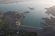
| Dahla Dam | |
|---|---|
 Aerial view of the Dahla Dam in 2012 | |
| Location | Shah Wali Kot District, Kandahar Province, Afghanistan |
| Coordinates | 31°51′20″N 65°53′33″E / 31.855544°N 65.892413°E |
| Opening date | 1952[1] |
| Dam and spillways | |
| Impounds | Arghandab River |
| Height | 55 metres |
| Length | 535 metres |
The Dahla Dam, also known as Arghandab Dam and Kasa,[2] is located in the Shah Wali Kot District of Kandahar Province in Afghanistan, approximately 40 km (25 mi) northeast of the provincial capital Kandahar.[3] Its name derives from Dahla, which is the historical name of the area where the dam was built.[4] It is the second largest dam in Afghanistan after the Kajaki Dam in neighboring Helmand Province. In 2019, the Afghan government planned to spend $450 million in upgrading the dam. The project includes raising the dam's walls by around 13 meters so the reservoir could hold nearly a billion cubic meters of fresh water and installing three turbines to produce 22 megawatts (MW) of electricity.[5][6]
The Dahla Dam was built in 1952 on the Arghandab River, which flows over a length of 250 mi (400 km).[7] Over the decades its reservoir was subject to siltation, and its canal system reduced irrigation benefits. This necessitated undertaking rehabilitation of the dam which involved desiltation works and pertinent components of the project to improve the water delivery system; this component was completed during March 2012 with assistance provided by Canada. The second phase involved raising the height of the dam and the relevant dykes to compensate for the loss of storage in its reservoir due to siltation, and to achieve the full benefits of irrigation for which the dam was originally built.[8][9][10][11]
- ^ Cite error: The named reference
Helmand's Golden Agewas invoked but never defined (see the help page). - ^ "Ambitious development on fragile foundations: Criticalities of currentlarge dam construction in Afghanistan". www.academia.edu. 2014. p. 51. Retrieved 2019-04-01.
- ^ "Dahla Dam reconstruction gives hope to Kandahar farmers". Pajhwok Afghan News. February 24, 2011. Archived from the original on 2019-05-06. Retrieved 2019-05-06.
- ^ On the Road - Dahla Dam in Kandahar on YouTube (TOLO TV, Jan. 6, 2023) (@39:07)
- ^ "ADB Grant to Improve Water Resources, Enhance Productivity in Afghanistan". Asian Development Bank. 11 September 2019. Retrieved 2024-04-04.
- ^ Cite error: The named reference
Ministry To Invest $450 Million In Kandahar Dam Projectwas invoked but never defined (see the help page). - ^ Cite error: The named reference
Waterwas invoked but never defined (see the help page). - ^ "Dahla Dam's future at risk as Canada ends work in Afghanistan: report". Canada: CBC News. 15 November 2014. Retrieved 2014-11-15.
- ^ "Project profile: Arghandab Irrigation System Rehabilitation". Foreign Affairs, Trade and Development Canada. Archived from the original on 4 March 2016. Retrieved 2015-11-12.
- ^ Melliger, Joshua J. "Identifying and Evaluating Irrigation Dams in Afghanistan" (PDF). Society of American Military Engineers, Society of American Military Engineers Omaha Post. Archived from the original (PDF) on 2016-03-04. Retrieved 2015-11-12.
- ^ "The Dahla Dam Project: A Status Update of a USA Funded Project in the Early 1950s for Agricultural Irrigation in the Kandahar Province, Afghanistan". Earth and Environment Science. 21 January 2015. Retrieved 2015-11-12.
