| Daisetsuzan National Park | |
|---|---|
| 大雪山国立公園 | |
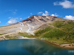
 Mount Asahi, Daisetsuzan National Park. | |
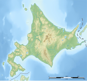
| Location | Hokkaidō, Japan |
| Coordinates | 43°39′37″N 142°51′29″E / 43.660278°N 142.858056°E |
| Area | 2,267.64 km2 (875.54 sq mi) |
| Established | December 4, 1934 |
| Visitors | 6,000,000[1] |
Daisetsuzan National Park (大雪山国立公園, Daisetsuzan Kokuritsu Kōen), or Taisetsuzan is located in the mountainous center of the northern Japanese island of Hokkaidō. At 2,267.64 square kilometres (875.54 sq mi), Daisetsuzan is the largest national park in Japan, and is approximately the size of Kanagawa Prefecture. Daisetsuzan, meaning "great snowy mountains", an apt description of these peaks. There are 16 peaks over 2,000 metres (6,600 ft) in Daisetsuzan National Park, both with and without trails. The park offers some of the most rugged scenery in Japan. Asahidake (2,290 metres (7,510 ft)), located in the north of the park, is the highest peak in Hokkaidō. Daisetsuzan National Park spans two subprefectures of Hokkaidō, Kamikawa and Tokachi. Daisetsuzan National Park was established in 1934.[2][3][4][5][6]
- ^ Ehrlich, Gretel (August 2008). "Between Volcanoes". Nationional Geographic Magazine. National Geographic Society. p. 2. Archived from the original on July 19, 2008. Retrieved 2008-08-11.
- ^ "Daisetsuzan National Park". Encyclopedia of Japan. Tokyo: Shogakukan. 2012. OCLC 56431036. Archived from the original on August 25, 2007. Retrieved 2012-08-28.
- ^ "大雪山国立公園" [Daisetsuzan National Park]. Dijitaru Daijisen (in Japanese). Tokyo: Shogakukan. 2012. OCLC 56431036. Archived from the original on August 25, 2007. Retrieved 2012-08-28.
- ^ "大雪山国立公園" [Daisetsuzan National Park]. Nihon Kokugo Daijiten (in Japanese). Tokyo: Shogakukan. 2012. OCLC 56431036. Archived from the original on August 25, 2007. Retrieved 2012-08-28.
- ^ "大雪山国立公園" [Daisetsuzan National Park]. Nihon Daihyakka Zensho (Nipponika) (in Japanese). Tokyo: Shogakukan. 2012. OCLC 153301537. Archived from the original on August 25, 2007. Retrieved 2012-08-28.
- ^ "大雪山国立公園" [Daisetsuzan National Park]. Nihon Rekishi Chimei Taikei (in Japanese). Tokyo: Shogakukan. 2012. OCLC 173191044. dlc 2009238904. Archived from the original on August 25, 2007. Retrieved 2012-08-28.

