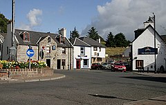
Dalmellington
| |
|---|---|
| Market town and civil parish | |
 Dalmellington Town Centre | |
Location within East Ayrshire | |
| Population | 1,340 (2022)[1] |
| OS grid reference | NS4764805958 |
| • Edinburgh | 64 mi (103 km) |
| • London | 317 mi (510 km) |
| Council area | |
| Lieutenancy area |
|
| Country | Scotland |
| Sovereign state | United Kingdom |
| Post town | AYR |
| Postcode district | KA6 |
| Dialling code | 01292 |
| Police | Scotland |
| Fire | Scottish |
| Ambulance | Scottish |
| UK Parliament | |
| Scottish Parliament | |
Dalmellington (Scots: Dawmellinton,[2] Scottish Gaelic: Dail M'Fhaolain)[3] is a market town and civil parish in East Ayrshire, Scotland.
In 2001, the town had a population of 1,407.[4] The town owes its origins to the fault line separating the Southern Uplands of Scotland from the Central Lowlands. Dalmellington sits at the issue of a river from the uplands into Dalmellington Moss plain.
The town has a history as a rest area, market town, weaving centre and mining village. The Chalmerston open cast coal mine to the north of the village covered some 742 hectares, but the operations have now ceased and the first phase of the site restoration has been completed. The town used to have a working museum to record the history of the area, but it was closed in January 2017.
- ^ "Mid-2020 Population Estimates for Settlements and Localities in Scotland". National Records of Scotland. 31 March 2022. Retrieved 31 March 2022.
- ^ "The Online Scots Dictionary - Read the Scots Dictionary". Scots-online.org. Retrieved 5 April 2015.[permanent dead link]
- ^ "Rannsaich an Stòr-dàta Briathrachais Gàidhlig" (in Scottish Gaelic). Smo.uhi.ac.uk. 18 December 2013. Retrieved 5 April 2015.
- ^ "Browser Population". Scrol.gov.uk. Archived from the original on 22 May 2014. Retrieved 5 April 2015.
