Danbury, North Carolina | |
|---|---|
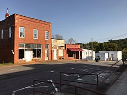
 Buildings along Courthouse Circle in Danbury | |
 Location of Danbury, North Carolina | |
| Coordinates: 36°24′40″N 80°12′43″W / 36.41111°N 80.21194°W | |
| Country | United States |
| State | North Carolina |
| County | Stokes |
| Founded | 1851 |
| Incorporated | 1957 |
| Named for | A plantation owned by Alexander Martin[1] |
| Government | |
| • Type | Mayor-Council |
| • Mayor | Janet Whitt |
| Area | |
• Total | 0.75 sq mi (1.95 km2) |
| • Land | 0.75 sq mi (1.94 km2) |
| • Water | 0.00 sq mi (0.01 km2) |
| Elevation | 778 ft (237 m) |
| Population (2020) | |
• Total | 189 |
| • Density | 252.00/sq mi (97.30/km2) |
| Time zone | UTC-5 (Eastern (EST)) |
| • Summer (DST) | UTC-4 (EDT) |
| ZIP code | 27016 |
| Area code | 336 |
| FIPS code | 37-16240[4] |
| GNIS feature ID | 2406352[3] |
| Website | www |
Danbury is a city located in Danbury Township, Stokes County, North Carolina, United States. As of the 2020 census, the city had a total population of 142.[5] It is the county seat of Stokes County. Danbury is located on North Carolina Highway 8/89 approximately 20 miles (32 km) north of Winston-Salem and is the "Gateway to Hanging Rock". The Stokes County Government Center, Arts Council, school board, county jail, a public library, a post office, and other public services are found within the town limits. LifeBrite Community Hospital of Stokes is located about a half mile northwest of the town. North Stokes High School, a big part of town, is located 7.4 miles to the northwest (North NC Highway 89 to Piney Grove Church Road, then left onto North Stokes School Road).
Danbury is a popular rest stop for bicyclists, motorcyclists, and driving enthusiasts due to the numerous scenic roads in Stokes County. Danbury also attracts outdoor enthusiasts because of its location on the Dan River and near the entrance to Hanging Rock State Park.
There are no regional or national franchises in Danbury, only local shops like the Danbury General Store, and small restaurants. J.E.Priddy's General Store, a local historic landmark dating from the late 19th century, is still in business selling goods old and new. It is located about 2 miles (3.2 km) east of town on Sheppard Mill Rd.
- ^ "North Carolina Gazetteer". Retrieved November 24, 2023.
- ^ "ArcGIS REST Services Directory". United States Census Bureau. Retrieved September 20, 2022.
- ^ a b U.S. Geological Survey Geographic Names Information System: Danbury, North Carolina
- ^ "U.S. Census website". United States Census Bureau. Retrieved January 31, 2008.
- ^ "City and Town Population Totals: 2020-2021". Census.gov. US Census Bureau. Retrieved July 9, 2022.