Danbury | |
|---|---|
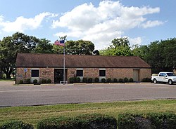
 Danbury City Hall. April 2012 | |
| Motto: Small Town Big heart | |
 Location of Danbury, Texas | |
 | |
| Coordinates: 29°13′42″N 95°20′42″W / 29.22833°N 95.34500°W | |
| Country | United States |
| State | Texas |
| County | Brazoria |
| Area | |
| • Total | 0.97 sq mi (2.51 km2) |
| • Land | 0.97 sq mi (2.51 km2) |
| • Water | 0.00 sq mi (0.00 km2) |
| Elevation | 23 ft (7 m) |
| Population (2020) | |
| • Total | 1,671 |
| • Density | 1,816.31/sq mi (701.03/km2) |
| Time zone | UTC-6 (Central (CST)) |
| • Summer (DST) | UTC-5 (CDT) |
| ZIP code | 77534 |
| Area code | 979 |
| FIPS code | 48-19120[2] |
| GNIS feature ID | 1355621[3] |
| Website | https://www.danburytx.gov |
Danbury is a city in Brazoria County, Texas, United States. It is located northeast of Angleton along the Union Pacific Railroad and County Road 171. The city boasts its own school district. The population was 1,671 at the 2020 census.[4]
- ^ "2019 U.S. Gazetteer Files". United States Census Bureau. Retrieved August 7, 2020.
- ^ "U.S. Census website". United States Census Bureau. Retrieved January 31, 2008.
- ^ "Danbury". Geographic Names Information System. United States Geological Survey, United States Department of the Interior. Retrieved September 6, 2024.
- ^ "Danbury, Texas Population History | 1990 - 2017".