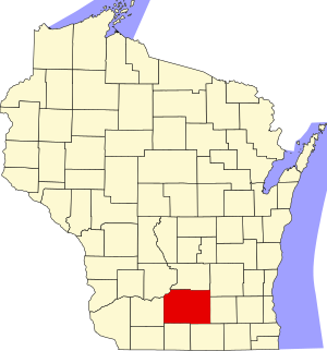
Dane County | |
|---|---|
 | |
 Location within the U.S. state of Wisconsin | |
 Wisconsin's location within the U.S. | |
| Coordinates: 43°04′N 89°25′W / 43.07°N 89.42°W | |
| Country | |
| State | |
| Founded | 1836 |
| Named for | Nathan Dane |
| Seat | Madison |
| Largest city | Madison |
| Government | |
| • Executive | Jamie Kuhn (interim) |
| Area | |
• Total | 1,238 sq mi (3,210 km2) |
| • Land | 1,197 sq mi (3,100 km2) |
| • Water | 41 sq mi (110 km2) 3.3% |
| Population (2020) | |
• Total | 561,504 |
• Estimate (2023) | 575,347 |
| • Density | 450/sq mi (180/km2) |
| Time zone | UTC−6 (Central) |
| • Summer (DST) | UTC−5 (CDT) |
| Congressional district | 2nd |
| Website | www |
Dane County is a county in the U.S. state of Wisconsin. As of the 2020 census, the population was 561,504, making it the second-most populous county in Wisconsin after Milwaukee County.[1] The county seat is Madison,[2] which is also the state capital. Dane County is the central county of the Madison metropolitan area, as well as the Madison–Janesville–Beloit combined statistical area.
- ^ "Dane County, Wisconsin Demographics and Housing 2020 Decennial Census".
- ^ "Find a County". National Association of Counties. Archived from the original on May 31, 2011. Retrieved June 7, 2011.
