Dargaville
Tākiwira (Māori) | |
|---|---|
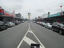
 Victoria Street in Dargaville (2015) | |
| Motto: Heart of the Kauri Coast | |
 | |
| Coordinates: 35°56′18″S 173°52′18″E / 35.93833°S 173.87167°E | |
| Country | New Zealand |
| Region | Northland Region |
| District | Kaipara District |
| Ward | Wairoa Ward |
| Electorates | |
| Government | |
| • Territorial Authority | Kaipara District Council |
| • Regional council | Northland Regional Council |
| Area | |
| • Total | 12.86 km2 (4.97 sq mi) |
| Population (June 2024)[2] | |
| • Total | 5,230 |
| • Density | 410/km2 (1,100/sq mi) |
| Postcode(s) | 0310 |
Dargaville (Māori: Tākiwira[3]) is a town located in the North Island of New Zealand. It is situated on the bank of the Northern Wairoa River in the Kaipara District of the Northland region. Dargaville is located 55 kilometres (34 mi) southwest of Whangārei, and 174 kilometres (108 mi) north of Auckland.
Dargaville is noted for the high proportion of residents of Croatian descent.[4] The area around it is one of the chief regions in the country for cultivating kūmara (sweet potato) and so Dargaville is known by many locals as the "Kūmara capital" of New Zealand.[5]
- ^ Cite error: The named reference
Areawas invoked but never defined (see the help page). - ^ "Aotearoa Data Explorer". Statistics New Zealand. Retrieved 26 October 2024.
- ^ "Tākiwira – te Aka Māori Dictionary".
- ^ "Dargaville | NZHistory, New Zealand history online". nzhistory.govt.nz. Retrieved 16 September 2022.
- ^ Taonga, New Zealand Ministry for Culture and Heritage Te Manatu. "Dargaville and the Northern Wairoa". teara.govt.nz. Retrieved 16 September 2022.