Native name: Erub | |
|---|---|
 A satellite image of Darnley Island | |
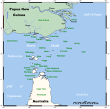
 A map of the Torres Strait Islands showing Erub in the north-eastern waters of Torres Strait | |
| Geography | |
| Location | Torres Strait |
| Coordinates | 9°35′13″S 143°46′16″E / 9.587°S 143.771°E |
| Archipelago | Torres Strait Islands |
| Total islands | 1 |
| Administration | |
Australia | |
| State | Queensland |
| Demographics | |
| Population | 400 |
| Darnley Island / Erub Island Queensland | |
|---|---|
| Coordinates | 9°35′06″S 143°46′12″E / 9.585°S 143.7699°E |
| Population | 326 (2021 census)[1] |
| • Density | 57.2/km2 (148.1/sq mi) |
| Postcode(s) | 4875 |
| Area | 5.7 km2 (2.2 sq mi) |
| Time zone | AEST (UTC+10:00) |
| Location |
|
| LGA(s) | Torres Strait Island Region |
| State electorate(s) | Cook |
| Federal division(s) | Leichhardt |

Darnley Island or Erub in the native Papuan language, Meriam Mir, is an island formed by volcanic action and situated in the eastern section of the Torres Strait, Queensland, Australia.[2] It is one of the Torres Strait Islands and is located near the Great Barrier Reef and just south of the Bligh entrance. The town on the island is also called Darnley, but the locality is called Erub Island, both being within the local government area of Torres Strait Island Region.[3][4] In the 2021 census, Erub Island had a population of 326 people, with 292 (89.6%) identifying as Indigenous Australians.[1]
The effective community language is Brokan (Torres Strait Creole), though many people also still speak Meriam Mir, the traditional language.
- ^ a b Cite error: The named reference
Census2021was invoked but never defined (see the help page). - ^ "Darnley Island – island (entry 9371)". Queensland Place Names. Queensland Government. Retrieved 8 April 2014.
- ^ "Darnley Island – town (entry 9372)". Queensland Place Names. Queensland Government. Retrieved 8 April 2014.
- ^ "Erub Island – locality (entry 46716)". Queensland Place Names. Queensland Government. Retrieved 9 March 2017.
