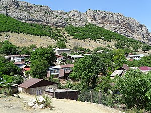
Dashalty / Karin Tak
Daşaltı / Քարին Տակ | |
|---|---|
 Village in June 2015 | |
| Coordinates: 39°44′30″N 46°44′57″E / 39.74167°N 46.74917°E | |
| Country | |
| District | Shusha |
| Population (2015)[1] | |
| • Total | 660 |
| Time zone | UTC+4 (AZT) |
Dashalty (Azerbaijani: Daşaltı) or Karin Tak (Armenian: Քարին Տակ) is a village in the Shusha District of Azerbaijan, in the region of Nagorno-Karabakh. Until 2020, the village was controlled by the Republic of Artsakh. The village had an ethnic Armenian-majority population prior to the 2020 Nagorno-Karabakh war, and also had an Armenian majority in 1989.[2]
About 3 km downriver there is a mossy waterfall named "Zontik" (Russian: Зонтик, literally, "Umbrella"), because of its resemblance to an umbrella in the rain. The village is an overnight stopping point along the Janapar hiking trail.
As of 2024, the entire village of Karin Tak has been razed to the ground by Azerbaijan.[3]
- ^ Hakob Ghahramanyan. "Directory of socio-economic characteristics of NKR administrative-territorial units (2015)".
- ^ Андрей Зубов. "Андрей Зубов. Карабах: Мир и Война". drugoivzgliad.com.
- ^ ""New reports emerge of damage to Armenian heritage in Karabakh"". civilnet.am.
