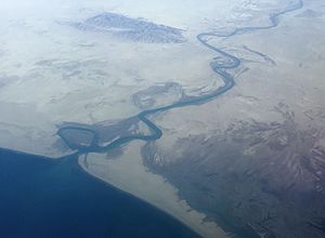
| Dasht River Dasht Kaur[1] | |
|---|---|
 Dasht river running into the Jiwani Bay near the border with Iran | |
 | |
| Native name | دریائے دشت (Urdu) |
| Location | |
| Countries | Pakistan |
| Provinces | Balochistan |
| Districts | Kech, Gwadar |
| Settlements | Kuldan, Sutkagan Dor |
| Physical characteristics | |
| Source | Mirani Dam |
| Mouth | |
• location | Gwadar District, Balochistan, Pakistan |
• coordinates | 25°10′46″N 61°40′39″E / 25.17944°N 61.67750°E |
• elevation | 0 m (0 ft) |
| Length | 430 km (270 mi)[2] |
| Basin size | 31,058.3 km2 (11,991.7 sq mi)[2] |
| Discharge | |
| • location | Near mouth |
| • average | (Period: 1971–2000)41.8 m3/s (1,480 cu ft/s)[2] |
| Basin features | |
| Progression | Arabian Sea |
| River system | Dasht River |
| Tributaries | |
| • left | Kech[3] |
| • right | Nihing[3] |
| Type | Intermittent river[1] |
The Dasht River (Urdu: دریائے دشت) is located in the Makran region and Gwadar District, in the southwestern section of Balochistan Province, Pakistan which drains near Jiwani.[4]
- ^ a b Pernetta, John. Marine Protected Area Needs in the South Asian Seas Region: Pakistan. IUCN. ISBN 9782831701776. Retrieved 17 May 2017.
- ^ a b c "Arabian Sea Coast".
- ^ a b (Pakistan), Baluchistan (1907). Baluchistan District Gazetteer Series. Bombay Education Society's Press. Retrieved 17 May 2017.
dasht river.
- ^ Rivers Network.org: Dasht River Basin Archived 2013-04-15 at archive.today.