| Dawson | |
|---|---|
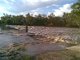
 Dawson River near Moura | |
Location of Dawson River mouth in Queensland | |
| Etymology | In honour of Robert Dawson[1] |
| Location | |
| Country | Australia |
| State | Queensland |
| Region | Central Queensland |
| Towns | Baralaba, Theodore, Taroom |
| Physical characteristics | |
| Source | Carnarvon Range |
| • location | northwest of Upper Dawson |
| • coordinates | 25°17′52″S 148°34′03″E / 25.29778°S 148.56750°E |
| • elevation | 642 m (2,106 ft) |
| Mouth | confluence with the Mackenzie River to form the Fitzroy River |
• location | northeast of Duaringa |
• coordinates | 24°57′50″S 150°04′23″E / 24.96389°S 150.07306°E |
• elevation | 55 m (180 ft) |
| Length | 735 km (457 mi) |
| Basin size | 50,800 km2 (19,600 sq mi) |
| Basin features | |
| River system | Fitzroy River |
| Tributaries | |
| • right | Don River (Central Queensland) |
| National parks | Carnarvon National Park; Expedition National Park; Precipice National Park |
| [2] | |
The Dawson River is a river in Central Queensland, Australia.[3]
- ^ Cite error: The named reference
QPNwas invoked but never defined (see the help page). - ^ "Map of Dawson River, QLD". Bonzle Digital Atlas of Australia. Archived from the original on 23 September 2015. Retrieved 19 November 2015.
- ^ "Dawson River – watercourse in Central Highlands Region (entry 9457)". Queensland Place Names. Queensland Government. Retrieved 6 May 2019.
