Daykundi
دایکندی | |
|---|---|
 The town of Nili, the provincial center of Daykundi | |
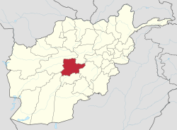
 Map of Afghanistan with Daikundi highlighted | |
| Coordinates: 33°45′N 66°15′E / 33.75°N 66.25°E | |
| Country | |
| Established | 2004 |
| Capital | Nili |
| Government | |
| • Governor | Aminullah Zubair[1] |
| • Deputy Governor | Haji Sahib Rashid [2] |
| Area | |
• Total | 18,088 km2 (6,984 sq mi) |
| Population (2021)[4] | |
• Total | 525,529 |
| Time zone | UTC+4:30 (Afghanistan Time) |
| Postal code | 42XX |
| ISO 3166 code | AF-DAY |
| Main languages | Persian (Dari and Hazaragi) |
| Website | daikundi |
Daykundi (Dari: دایکندی), also spelled as Daikundi, Daikondi, or Daykondi, is one of the thirty-four provinces of Afghanistan, located in the central part of the country. It has a population of about 516,504 and is a Hazara dominated province.[5]
Daykundi Province was carved out of the northern part of Uruzgan Province in 2004, becoming a separate province. It falls into the traditionally ethnic Hazara region known as the Hazaristan in the highlands of central Afghanistan with the provincial capital, Nili. It is surrounded by Bamyan Province in the northeast, Ghazni Province in the southeast, Uruzgan Province in the south, Helmand Province in the southwest, and Ghor Province in the northwest.
- ^ "Over 800 Hazara Families Ordered Out Of Their Homes By Taliban". NDTV.com. Retrieved 2021-09-24.
- ^ "د نږدې شلو ولایاتو لپاره نوي والیان او امنیې قوماندانان وټاکل شول". November 7, 2021.
- ^ "Statoids". Retrieved 2018-07-19.
- ^ "Estimated Population of Afghanistan 2021-22" (PDF). National Statistic and Information Authority (NSIA). April 2021. Archived from the original (PDF) on June 24, 2021. Retrieved June 21, 2021.
- ^ "Estimated Population of Afghanistan 2020-21" (PDF). Islamic Republic of Afghanistan, National Statistics and Information Authority. Archived from the original (PDF) on 3 July 2020. Retrieved 6 June 2021.