| De Hoge Veluwe National Park | |
|---|---|
| Nationaal Park De Hoge Veluwe | |
 | |
 Location of De Hoge Veluwe | |
| Location | Gelderland, Netherlands |
| Nearest city | Arnhem |
| Coordinates | 52°5′N 5°48′E / 52.083°N 5.800°E |
| Area | 55 km2 (21 sq mi) |
| Established | 1935 [1] |
| Governing body | Stichting Het Nationale Park De Hoge Veluwe |
| www | |
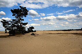
De Hoge Veluwe National Park (Dutch pronunciation: [də ˈɦoːɣə ˈveːlyʋə]; "The High Veluwe") is a Dutch national park in the province of Gelderland near the cities of Ede, Wageningen, Arnhem and Apeldoorn. It is approximately 55 km2 (14,000 acres; 21 sq mi) in area, consisting of heathlands, sand dunes, and woodlands. It is situated in the Veluwe, the area of the largest terminal moraine in the Netherlands. Most of the landscape of the park and the Veluwe was created during the last ice age. The alternating sand dune areas and heathlands may have been caused by human utilization of the surrounding lands. The park forms one of the largest continuous nature reserves in the Netherlands.
- ^ "History". Stichting Het Nationale Park De Hoge Veluwe. Archived from the original on 2009-03-21. Retrieved 2009-07-18.