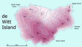
Nickname: Big Witch | |
|---|---|
 Detailed map of De Witt Island | |
| Etymology | Cornelis Jan Witsen, a Commissioner of the Dutch East India Company[1] |
| Geography | |
| Location | South West Tasmania |
| Coordinates | 43°35′24″S 146°21′00″E / 43.59000°S 146.35000°E |
| Archipelago | Maatsuyker Islands Group |
| Adjacent to | Southern Ocean |
| Area | 516 ha (1,280 acres)[2]: 18 |
| Width | 3 km (1.9 mi)[3] |
| Highest elevation | 340 m (1120 ft)[3] |
| Administration | |
Australia | |
| State | Tasmania |
| Region | South West |
| Demographics | |
| Population | Unpopulated |
| Additional information | |
| Register of the National Estate | |
De Witt Island, also known as Big Witch, is an island located close to the south-western coast of Tasmania, Australia. The 516-hectare (1.99 sq mi) island is the largest of the Maatsuyker Islands Group, and comprises part of the Southwest National Park and the Tasmanian Wilderness World Heritage Site. The island is listed on the Australian Register of the National Estate.[2]
- ^ Heeres, J. E., ed. (2006). "Abel Janszoon Tasman's Journal of his Discovery of Van Diemen's Land and New Zealand in 1642 with Documents Relating to his Exploration of Australia in 1644...to which are added his Life and Labours, 1898". Project Gutenberg of Australia]. Retrieved 9 July 2006.
- ^ a b Cite error: The named reference
CONSERVATIONwas invoked but never defined (see the help page). - ^ a b Dixon, G.; Houshold, I (1996). "Notes on the geology and geomorphology of De Witt Island, southwest Tasmania". Papers and Proceedings of the Royal Society of Tasmania. 130 (1): 67–74. doi:10.26749/rstpp.130.1.67. ISSN 0080-4703.
