This article needs additional citations for verification. (December 2019) |

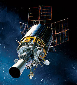
The Defense Support Program (DSP) is a program of the United States Space Force that operated the reconnaissance satellites which form the principal component of the Satellite Early Warning System used by the United States.
DSP satellites, which are operated by the 460th Space Wing, detect missile or spacecraft launches and nuclear explosions using sensors that detect the infrared emissions from these intense sources of heat. During Desert Storm, for example, DSP was able to detect the launches of Iraqi Scud missiles and provide timely warnings to civilians and military forces in Israel and Saudi Arabia.[1]
The satellites are in geosynchronous orbits, and are equipped with infrared sensors operating through a wide-angle Schmidt camera. The entire satellite spins so that the linear sensor array in the focal plane scans over the Earth six times every minute.[2]
Typically, DSP satellites were launched on Titan IVB boosters with Inertial Upper Stages. However, one DSP satellite (DSP-16) was launched using the Space Shuttle Atlantis on mission STS-44 (24 November 1991).
The last known DSP satellite (flight 23) was launched in 2007 aboard the first operational flight of the Delta IV Heavy rocket, as the Titan IV had been retired in 2005. All 23 satellites were built by the prime contractor Northrop Grumman Aerospace Systems, formerly TRW, in Redondo Beach, California.[3]
The 460th Space Wing, with headquarters at Buckley Space Force Base, Colorado, has units, primarily the 2nd Space Warning Squadron, that operate DSP satellites and report warning information, via communications links, to the NORAD and USSTRATCOM early warning centers within the Cheyenne Mountain Space Force Station, Colorado. These centers immediately forward data to various agencies and areas of operations around the world.[citation needed]
The SBIRS Wing at the Space Systems Command, Los Angeles Space Force Base, California is responsible for development and acquisition of the satellites.[4]
- ^ "Defense Support program". Fas.org. Archived from the original on 8 August 2014. Retrieved 26 October 2013.
 This article incorporates text from this source, which is in the public domain.
- ^ "Factsheets : DSP Animation Only". afspc.af.mil. 19 July 2007. Archived from the original on 29 October 2013. Retrieved 26 October 2013.
 This article incorporates text from this source, which is in the public domain.
- ^ https://fas.org/sgp/crs/weapons/RS21148.pdf
 This article incorporates text from this source, which is in the public domain.
- ^ "Factsheets : Infrared Space Systems Directorate". Losangeles.af.mil. 21 November 2012. Archived from the original on 24 August 2013. Retrieved 26 October 2013.
 This article incorporates text from this source, which is in the public domain.