Deir Mimas
دير ميماس | |
|---|---|
Town | |
 Deir Mimas | |
| Coordinates: 33°18′7″N 35°32′43″E / 33.30194°N 35.54528°E | |
| Grid position | 131/151 L |
| Country | |
| Governorate | Nabatieh Governorate |
| District | Marjeyoun District |
| Government | |
| • Mayor | Dr. Georges Nakad |
| Highest elevation | 650 m (2,130 ft) |
| Lowest elevation | 550 m (1,800 ft) |
| Time zone | UTC+2 (EET) |
| • Summer (DST) | UTC+3 (EEST) |
| Dialing code | +961 |
| Website | http://www.deirmimas-lb.com/ |
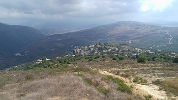
Deir Mimas (also spelled Deirmimas, Deir Mamas, and Deir Mimmas) (دير ميماس) is a town 88 km south of Beirut in Lebanon. Named in honor of Saint Mamas, the town overlooks the Litani River and the medieval Beaufort Castle to the west and the snow-capped summits of Mount Hermon to the east. It has a population of around 4,600 people.[1]
- ^ دير ميماس في تقرير للـ OTV من رونيت ضاهر, 29 March 2015, retrieved 2022-06-10
