Delila, Virginia | |
|---|---|
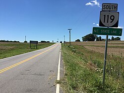
 View south along Highway 119 (Calvary Road) at US 58 / US 360 (Philpott Road) | |
| Coordinates: 36°35′04″N 79°08′26″W / 36.5845°N 79.1405°W | |
| Country | United States |
| State | Virginia |
| County | Halifax |
| Elevation | 506 ft (154 m) |
| Time zone | UTC−5 (Eastern (EST)) |
| • Summer (DST) | UTC−4 (EDT) |
| ZIP code | 24520 |
| Area code | 434 |
| GNIS feature ID | 1477255 |
Delila is a rural unincorporated community in the southwest corner of Halifax County in the U.S. state of Virginia, located on ![]() US 360 /
US 360 / ![]() US 58 (Philpott Highway) at its intersection with SR 119 (Calvary Road) and SR 694 (Medley Road). Delila is 3 miles north of the North Carolina state line, 1 mile east of the Dan River, and roughly halfway between Danville and South Boston, Virginia. The nearest volunteer fire department to Delila is in Turbeville, approximately 7 miles (11 km) northeast of Delila.
US 58 (Philpott Highway) at its intersection with SR 119 (Calvary Road) and SR 694 (Medley Road). Delila is 3 miles north of the North Carolina state line, 1 mile east of the Dan River, and roughly halfway between Danville and South Boston, Virginia. The nearest volunteer fire department to Delila is in Turbeville, approximately 7 miles (11 km) northeast of Delila.

