Denali Borough | |
|---|---|
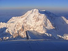
 Denali, also known as Mount McKinley, its former official name. | |
 Location within the U.S. state of Alaska | |
 Alaska's location within the U.S. | |
| Coordinates: 63°47′20″N 150°11′30″W / 63.788888888889°N 150.19166666667°W | |
| Country | |
| State | |
| Incorporated | December 7, 1990[1] |
| Named for | Denali |
| Seat | Healy |
| Largest CDP | Healy |
| Area | |
• Total | 12,777 sq mi (33,090 km2) |
| • Land | 12,751 sq mi (33,020 km2) |
| • Water | 26 sq mi (70 km2) 0.2% |
| Population (2020) | |
• Total | 1,585 |
| • Density | 0.12/sq mi (0.048/km2) |
| Time zone | UTC−9 (Alaska) |
| • Summer (DST) | UTC−8 (ADT) |
| Congressional district | at-large |
| Website | www |
The Denali Borough is a borough located in the U.S. state of Alaska. As of the 2020 census the population of the borough was 1,619, down from 1,826 in 2010.[2][3] The borough seat and most populated community is Healy,[4] and its only incorporated place is Anderson. The borough was incorporated in December 1990.
The area was previously a part of the Unorganized Borough, with the Upper Railbelt School District serving as the region's rural education attendance area (which was replaced by a school district under the borough's umbrella upon incorporation).
The earliest inhabitants were nomadic native Alaskans. A mining camp was established near Healy prior to 1902, and construction of the Alaska Railroad brought additional settlers to the area in the early 1920s. Clear Space Force Station, the Usibelli Coal Mine and tourism at the Denali National Park and Preserve have brought growth and development.[5]
- ^ 1996 Alaska Municipal Officials Directory. Juneau: Alaska Municipal League/Alaska Department of Community and Regional Affairs. January 1996. p. 4.
- ^ "2020 Census Data - Cities and Census Designated Places" (Web). State of Alaska, Department of Labor and Workforce Development. Retrieved October 31, 2021.
- ^ "State & County QuickFacts". United States Census Bureau. Archived from the original on June 6, 2011. Retrieved May 18, 2014.
- ^ "Denali Borough, Alaska". National Association of Counties. Archived from the original on November 6, 2021. Retrieved November 6, 2021.
- ^ "The History of Denali Borough, Alaska". ExploreNorth. Retrieved November 6, 2021.
