Deogarh | |
|---|---|
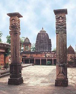
 The Shantinath Temple columns in the fort show Jain monks | |
| Coordinates: 24°31′34″N 78°14′17″E / 24.526°N 78.238°E | |
| Country | India |
| State | Uttar Pradesh |
| District | Lalitpur |
| Government | |
| • Body | Gram panchayat |
| Area | |
• Total | 10.49 km2 (4.05 sq mi) |
| Elevation | 211 m (692 ft) |
| Population (2011) | |
• Total | 783 |
| • Density | 75/km2 (190/sq mi) |
| Languages | |
| • Official | Hindi |
| Time zone | UTC+5:30 (IST) |
| PIN | 284403 |
| Telephone code | 0517 |
Deogarh is a village in Lalitpur district of the Indian state of Uttar Pradesh. It is located on the right bank of Betwa River and to the west of Lalitpur hills. It is known for Gupta monuments and for many ancient monuments of Jain origins inside and outside the walls of the fort.[1][2][3]
The fort on the hill is dominated by a cluster of Jain temples on its eastern part, the oldest of these dating to the 8th or 9th century. Apart from Jain temples, the wall frescoes of Jain images of "iconographic and the stylistic variety", are special features of the fort. The three ghats (ghat means "flight of stone steps leading to the river"), which provide approach to the Betwa river edge from the fort – the Nahar Ghat, the Rajghat and the ghat with the Siddh ki Ghufa (saints cave) – are also of archeological significance.
The Deogarh monuments are protected by the Department of Archaeology of the Archaeological Survey of India (ASI), and managed through its Northern Circle Office located in Agra. ASI maintain an archaeological museum at the Deogarh site, which is noted for its treasured archaeological sculptures.[4]
- ^ a b "District Census Handbook - Lalitpur" (PDF). Census of India. p. xiii,104. Retrieved 15 November 2015.
- ^ Titze, Kurt; Klaus Bruhn (1998). Jainism: a Pictorial guide to the religion of non-violence. Motilal Banarsidass Publ. pp. 102–106. ISBN 81-208-1534-3. Retrieved 3 January 2010.
{{cite book}}:|work=ignored (help) - ^ Universiteit van Amsterdam and Institute of South Asian Archaeology (1958). Studies in south Asian culture, Part 3. Brill Archive. pp. 1–29.
{{cite book}}:|work=ignored (help) - ^ Studies in south Asian culture, p. 7

