Deoghar District | |
|---|---|
From top, left to right: Baidyanath Temple, Trikut Hill, Ramakrishna Mission Vidyapith, Deoghar, Prayer at Thakur Anukulchandra Satsang Ashram, Deoghar Airport, Naulakha Temple | |
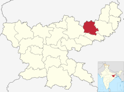
 Location of Deoghar district in Jharkhand | |
| Coordinates (Deoghar): 24°29′N 86°42′E / 24.483°N 86.700°E | |
| Country | |
| State | |
| Division | Santhal Pargana |
| Established | 15 November 2000 |
| Headquarters | Deoghar |
| Government | |
| • Deputy Commissioner | Shri Vishal Sagar (IAS)[1] |
| • Lok Sabha constituencies | 1.Dumka (shared with Dumka district) 2.Godda (shared with Godda district) |
| • Vidhan Sabha constituencies | 1.Deoghar, 2.Madhupur, 3.Sarath |
| Area | |
• Total | 2,478.61 km2 (957.00 sq mi) |
| Population (2011) | |
• Total | 1,492,073 |
| • Density | 600/km2 (1,600/sq mi) |
| • Urban | 258,361 |
| Languages | |
| • Official | Hindi |
| Demographics | |
| • Literacy | 64.85% |
| • Sex ratio | 925 |
| Time zone | UTC+05:30 (IST) |
| Major highways | NH 114A NH 133 |
| Website | https://deoghar.nic.in/ |
Deoghar district (pronounced, Devo ka ghar) is one of the twenty-four districts of Jharkhand state in eastern India. Deoghar, the central city of the district, is also its administrative headquarters. This district is known for the Baidyanath Jyotirlinga shrine and is a part of the Santhal Pargana division. Deoghar is a Hindi word meaning abode ('ghar') of the Gods and Goddesses ('dev'). Deoghar is also known as "Baidyanath Dham", and "Baba Dham",.


