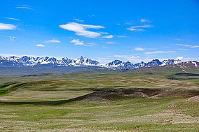
| Deosai National Park | |
|---|---|
| The Land of Giants[1] | |
 | |
 | |
| Location | Skardu District, Gilgit Baltistan, Pakistan |
| Nearest city | Skardu and Astore |
| Coordinates | 34°58′N 75°24′E / 34.967°N 75.400°E |
| Area | 358,400[2] ha (886,000 acres) |
| Average elevation | 4,114 m (13,497 ft) |
Deosai National Park (Urdu: دیوسائی باغ ملی) is a high-altitude alpine plain and national park located between the Skardu District and Astore District in Gilgit-Baltistan, Pakistan. Lying in the east of Nanga Parbat and in the western side of the Himalayas, closer to the central Karakoram Range surrounded by Deosai Mountains, the national park is in the tentative list under World Heritage Site of Pakistan.[3][4][5][6][7]
The Deosai Plains are situated at an average elevation of 4,114 metres (13,497 ft) above sea level.[8]
- ^ Cite error: The named reference
The Nationwas invoked but never defined (see the help page). - ^ "Deosai National Park". doam.gov.pk. Department of Archaeology and Museums - Government of Pakistan. Retrieved 10 November 2024.
- ^ "Deosai National Park". whc.unesco.org. World Heritage Convention, UNESCO. Retrieved 10 November 2024.
- ^ "NATIONAL PARKS - DEOSAI NATIONAL PARK". fweb.gov.pk. Forest, Wildlife & Environment Department Government of Gilgit-Baltistan. 5 January 2022. Retrieved 10 November 2024.
- ^ "Deosai National Park Skardu". Retrieved 31 July 2021.
- ^ Daud, Nyla (18 June 2023). "TRAVEL: A DEOSAI ADVENTURE". Dawn. Retrieved 10 November 2024.
- ^ Deosai Mountains. Encyclopedia Britannica. 10 September 2024. Retrieved 10 November 2024.
- ^ Öztürk, Münir; Hakeem, Khalid Rehman; Faridah-Hanum, I.; Efe, Recep (2015-05-05). Climate Change Impacts on High-Altitude Ecosystems. Springer. p. 456. ISBN 9783319128597.