This article needs additional citations for verification. (July 2015) |
This article possibly contains original research. (October 2021) |
Derai
দিরাই | |
|---|---|
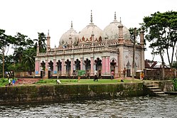
 Mosque in Bhatipara Zamindar Bari | |
 | |
| Country | |
| Division | Sylhet |
| District | Sunamganj |
| Thana | 1942 |
| Upazila | 1982 |
| Government | |
| • MP (Sunamganj-2) | Joya Sengupta |
| • Upazila Chairman | Muhammad Manzur Alam Chowdhury |
| Area | |
• Total | 420.93 km2 (162.52 sq mi) |
| Population | |
• Total | 253,705 |
| • Density | 600/km2 (1,600/sq mi) |
| Time zone | UTC+6 (BST) |
| Postal code | 3040[2] |
| Website | www |
Derai is an upazila (sub-district) of the Sunamganj District in northeastern Bangladesh, part of the Sylhet Division.[3]
- ^ National Report (PDF). Population and Housing Census 2022. Vol. 1. Dhaka: Bangladesh Bureau of Statistics. November 2023. p. 404. ISBN 978-9844752016.
- ^ "Bangladesh Postal Code". Dhaka: Bangladesh Postal Department under the Department of Posts and Telecommunications of the Ministry of Posts, Telecommunications and Information Technology of the People's Republic of Bangladesh. 20 October 2024.
- ^ Chanda, Jiban Kumar (2012). "Derai Upazila". In Sirajul Islam; Miah, Sajahan; Khanam, Mahfuza; Ahmed, Sabbir (eds.). Banglapedia: the National Encyclopedia of Bangladesh (Online ed.). Dhaka, Bangladesh: Banglapedia Trust, Asiatic Society of Bangladesh. ISBN 984-32-0576-6. OCLC 52727562. OL 30677644M. Retrieved 27 November 2024.