| Des Moines River | |
|---|---|
 The Des Moines River upstream of Ottumwa, Iowa | |
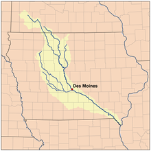
 The Des Moines River watershed | |
| Location | |
| Country | United States |
| State | Iowa, Minnesota, Missouri |
| Physical characteristics | |
| Source | Lake Shetek |
| • location | Murray County, Minnesota |
| • coordinates | 44°05′02″N 95°41′17″W / 44.0839°N 95.6881°W |
| • elevation | 1,483 ft (452 m) |
| Mouth | Mississippi River |
• location | Clark County, Missouri / Lee County, Iowa, near Keokuk, Iowa |
• coordinates | 40°22′52″N 91°25′21″W / 40.3812°N 91.4224°W |
• elevation | 597 ft (182 m) |
| Length | 525 mi (845 km) |
| Basin size | 14,802 sq mi (38,340 km2) |
| Discharge | |
| • location | St. Francisville, MO |
| • average | 13,223 cu/ft. per sec.[1] |
| U.S. Geological Survey Geographic Names Information System: Des Moines River | |
The Des Moines River (/dəˈmɔɪn/ ) is a tributary of the Mississippi River in the upper Midwestern United States that is approximately 525 miles (845 km) long from its farther headwaters.[2] The largest river flowing across the state of Iowa, it rises in southern Minnesota and flows across Iowa from northwest to southeast, passing from the glaciated plains into the unglaciated hills, transitioning near the capital city of Des Moines in the center of the state. The river continues to flow in a southeastern direction away from Des Moines, flowing directly into the Mississippi River. The Des Moines River forms a short portion of Iowa's border with Missouri between Lee County, Iowa and Clark County, Missouri.
The city of Des Moines, Iowa, was named for the river.
- ^ "USGS Surface Water data for Missouri: USGS Surface-Water Annual Statistics".
- ^ U.S. Geological Survey. National Hydrography Dataset high-resolution flowline data. The National Map Archived 2012-03-29 at the Wayback Machine, accessed May 26, 2011