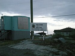
Dettah
Tʼèɂehdaà | |
|---|---|
Yellowknives Dene First Nation (Dettah) | |
 | |
| Coordinates: 62°24′40″N 114°18′30″W / 62.41111°N 114.30833°W[1] | |
| Country | Canada |
| Territory | Northwest Territories |
| Region | North Slave Region |
| Territorial electoral district | Tu Nedhé-Wiilideh |
| Census division | Region 6 |
| Government | |
| • Chief | Ernest Betsina |
| • Counilors | Anastassia Judas, Peter Crookedhand, Mary Rose Sundberg, Rosanna Sangris, & Liza Charlo-Pieper |
| • MLA | Richard Edjericon |
| Area | |
| • Land | 1.12 km2 (0.43 sq mi) |
| Elevation | 179 m (587 ft) |
| Population (2021)[2] | |
• Total | 192 |
| • Density | 171.9/km2 (445/sq mi) |
| Time zone | UTC−07:00 (MST) |
| • Summer (DST) | UTC−06:00 (MDT) |
| Canadian Postal code | |
| Area code | 867 |
| Telephone exchanges | 444 445 446 669 765 766 873 920 |
| Sources: Department of Municipal and Community Affairs,[3] Prince of Wales Northern Heritage Centre,[4] Canada Flight Supplement[5] | |
Dettah,[pronunciation?] sometimes spelled incorrectly as Detah,[6] is a First Nations[7] community in the North Slave Region of the Northwest Territories, Canada. Located just southeast of the capital of Yellowknife, it is a 6.5 km (4.0 mi) drive from that city by ice road across the north arm of Great Slave Lake in winter or a 27 km (17 mi) drive via the Ingraham Trail, year-round. The name T'é?ehdaá means 'Burnt Point' in the Wíílíídeh dialect and was simplified to Dettah when non-indigenous people couldnʼt pronounce it. The place was a common fishing spot for the Tetsǫ́tʼine (Yellowknives) people and is home to nearly 200 indigenous people.
- ^ "Dettah". Geographical Names Data Base. Natural Resources Canada.
- ^ a b Cite error: The named reference
2021censuswas invoked but never defined (see the help page). - ^ "NWT Communities - Dettah". Government of the Northwest Territories: Department of Municipal and Community Affairs. Retrieved 2017-10-29.
- ^ "Northwest Territories Official Community Names and Pronunciation Guide". Prince of Wales Northern Heritage Centre. Yellowknife: Education, Culture and Employment, Government of the Northwest Territories. Archived from the original on 2016-01-13. Retrieved 2016-01-13.
- ^ Canada Flight Supplement. Effective 0901Z 16 July 2020 to 0901Z 10 September 2020.
- ^ We've spelled this N.W.T. community's name wrong for almost 50 years
- ^ Differences in Community Government Structures

