| Devils Tower (Bear Lodge) | |
|---|---|
| Matȟó Thípila (Lakota), Daxpitcheeaasáao (Crow)[1] | |
 | |
| Highest point | |
| Elevation | 5,112 ft (1,558 m) NAVD 88[2] |
| Coordinates | 44°35′26″N 104°42′55″W / 44.59056°N 104.71528°W[3] |
| Geography | |
 | |
| Location | Crook County, Wyoming, United States |
| Parent range | Bear Lodge Mountains, part of the Black Hills |
| Topo map | USGS Devils Tower |
| Geology | |
| Mountain type | Laccolith |
| Climbing | |
| First ascent | William Rogers and Willard Ripley, July 4, 1893 |
| Easiest route | Durrance Route |
| Devils Tower National Monument | |
|---|---|
| Nearest city | Hulett, Wyoming |
| Coordinates | 44°35′26″N 104°42′55″W / 44.59056°N 104.71528°W |
| Area | 1,346 acres (5.45 km2)[5] |
| Established | September 24, 1906[6] |
| Visitors | 499,031 (in 2017)[7] |
| Governing body | National Park Service |
| Website | Devils Tower National Monument |
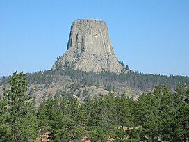
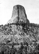
Devils Tower in 1900 (left), and red sandstone and siltstone cliffs above the Belle Fourche River (right)
Devils Tower (also known as Bear Lodge)[8] is a butte, possibly laccolithic, composed of igneous rock in the Bear Lodge Ranger District of the Black Hills, near Hulett and Sundance in Crook County, northeastern Wyoming, above the Belle Fourche River. It rises 1,267 feet (386 m) above the Belle Fourche River, standing 867 feet (264 m) from summit to base. The summit is 5,112 feet (1,558 m) above sea level.
Devils Tower National Monument was the first United States national monument, established on September 24, 1906, by President Theodore Roosevelt.[9] The monument's boundary encloses an area of 1,347 acres (545 ha).
- ^ "Apsáalooke Place Names Database". Little Big Horn College. Retrieved May 24, 2020.
- ^ "Devils Tower, Wyoming". Peakbagger.com. Retrieved December 14, 2012.
- ^ "Devils Tower". Geographic Names Information System. United States Geological Survey, United States Department of the Interior. Retrieved December 14, 2012.
- ^ "Devils Tower in United States of America". Protected Planet. IUCN. Retrieved November 2, 2018.
- ^ "Listing of acreage – December 31, 2011" (XLSX). Land Resource Division, National Park Service. Retrieved May 13, 2012. (National Park Service Acreage Reports)
- ^ . September 24, 1906 – via Wikisource.
- ^ "NPS Annual Recreation Visits Report". National Park Service. Retrieved February 20, 2019.
- ^ "Mato Tipila, or Bear's Lodge, the stunning monolith of stone in northeastern Wyoming that settlers dubbed 'Devil's Tower.'" Jason Mark, Satellites in the High Country: Searching for the Wild in the Age of Man (2015), p. 166. "Devil's Tower, beyond the Black Hills, forms the Buffalo's Head, with the face, Bear Butte as the Buffalo's Nose, and Inyan Kaga as the Black Buffalo Horn." Jessica Dawn Palmer, The Dakota Peoples: A History of the Dakota, Lakota and Nakota through 1863 (2011), p. 203.
- ^ "Devils Tower First 50 Years" (PDF). National Park Service. Archived (PDF) from the original on May 31, 2009. Retrieved October 11, 2014.


