This article needs additional citations for verification. (March 2018) |
Dhakuria | |
|---|---|
| Coordinates: 22°30′37″N 88°22′16″E / 22.5104°N 88.3711°E | |
| Country | |
| State | West Bengal |
| City | Kolkata |
| District | Kolkata[1][2][3] |
| Kolkata Suburban Railway | Dhakuria railway station |
| Metro Station | Kalighat, Rabindra Sarobar, Hemanta Mukherjee and Kavi Sukanta |
| Municipal Corporation | Kolkata Municipal Corporation |
| KMC wards | 90, 91, 92, 93 |
| Time zone | UTC+5:30 (IST) |
| Area code | +91 33 |
| Lok Sabha constituency | Kolkata Dakshin |
| Vidhan Sabha constituency | Rashbehari, Kasba |
Dhakuria is a neighborhood of Kolkata (Calcutta) in West Bengal, India. It is located in the southern part of the city and is surrounded by Ballygunge and Kasba in the north, Haltu in the east, Jadavpur/ Garia in the south and Lake Gardens/ Jodhpur Park in the west. Dhakuria has emerged as a notable neighborhood in South Kolkata, characterized by significant urban development. The area has seen substantial growth in recent years, marked by:
Commercial expansion: Various businesses and retail establishments have been established in the locality. Residential growth: The construction of new housing complexes and apartments has increased the residential capacity of the area.
This combination of commercial and residential development has contributed to Dhakuria's rising prominence within the southern part of Kolkata, transforming it into a key urban center in the region.
It has a Postal Index Number (PIN) code of 700031. Some localities adjacent to Golpark and Jodhpur Park also have Postal Index Number (PIN) code of 700029 and 700068 respectively.
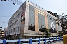
Prominent landmarks include Dhakuria railway station, bus terminal # 37, Manipal Hospital, Dhakuria and Dakshinapan Shopping Complex.

- ^ "Kolkata South district".
- ^ "South 24 Parganas district".
- ^ "Elector Details As On 30-10-2010" (PDF). Archived from the original (PDF) on 29 May 2013.
