| Dharruk Sydney, New South Wales | |||||||||||||||
|---|---|---|---|---|---|---|---|---|---|---|---|---|---|---|---|
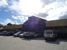
 West Tradies club in Dharruk | |||||||||||||||
 | |||||||||||||||
| Population | 2,806 (2021 census)[1] | ||||||||||||||
| Postcode(s) | 2770 | ||||||||||||||
| Elevation | 52 m (171 ft) | ||||||||||||||
| Location | 46 km (29 mi) west of Sydney CBD | ||||||||||||||
| LGA(s) | City of Blacktown | ||||||||||||||
| State electorate(s) | Mount Druitt | ||||||||||||||
| Federal division(s) | Chifley | ||||||||||||||
| |||||||||||||||
Dharruk (/dærʌk/) is a suburb of Sydney, in the state of New South Wales, Australia. It is located 46 kilometres west of the Sydney central business district, in the local government area of the City of Blacktown and is part of the Greater Western Sydney region.
Dharruk is chiefly a residential suburb with almost no industry or commercial activity. The only other significant activity is education, with the Mount Druitt campus of Chifley College and Dawson Public School located in the suburb. The boundaries of Dharruk are defined by Carlisle Avenue to the east, Popondetta Road to the west, Jersey Road to the north and Woodstock Avenue to the south.[2]
- ^ Australian Bureau of Statistics (28 June 2022). "Dharruk (State Suburb)". 2021 Census QuickStats. Retrieved 10 August 2024.
 Material was copied from this source, which is available under a Creative Commons Attribution 4.0 International License.
- ^ Cite error: The named reference
GNB Dharrukwas invoked but never defined (see the help page).