Dismal Swamp Canal | |
 A sailboat on the Dismal Swamp Canal | |
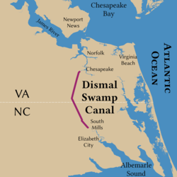
 Path of the canal | |
| Location | Runs between Chesapeake, Virginia, and South Mills, North Carolina |
|---|---|
| Coordinates | 36°33′24″N 76°22′50″W / 36.55667°N 76.38056°W |
| Area | 1,203 acres (487 ha) |
| Built | 1793–1805 |
| Architect | Dismal Swamp Canal Co.; US Army Corps of Engineers |
| MPS | Dismal Swamp Canal and Associated Development, Southeast Virginia and Northeast North Carolina MPS |
| NRHP reference No. | 88000528[1] |
| VLR No. | 131-0035 |
| Significant dates | |
| Added to NRHP | June 06, 1988 |
| Designated VLR | August 16, 1994[2] |
The Dismal Swamp Canal is a canal located along the eastern edge of the Great Dismal Swamp in Virginia and North Carolina in the United States. Opened in 1805, it is the oldest continually operating man-made canal in the United States. It is part of the Intracoastal Waterway.
- ^ "National Register Information System". National Register of Historic Places. National Park Service. March 13, 2009.
- ^ "Virginia Landmarks Register". Virginia Department of Historic Resources. Archived from the original on September 21, 2013. Retrieved June 5, 2013.