District Six
Zonnebloem, Kanaladorp | |
|---|---|
 | |
 Street map of District Six | |
| Country | South Africa |
| Province | Western Cape |
| Municipality | City of Cape Town |
| Main Place | Cape Town |
| Time zone | UTC+2 (SAST) |
| Postal code (street) | 7925 |
| Part of a series on |
| Apartheid |
|---|
 |


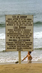
District Six (Afrikaans: Distrik Ses) is a former inner-city residential area in Cape Town, South Africa. In 1966, the apartheid government (the National Party) announced that the area would be razed and rebuilt as a "whites only" neighbourhood under the Group Areas Act.[1] Over the course of a decade, over 60,000 of its inhabitants were forcibly removed and in 1970 the area was renamed Zonnebloem, a name that makes reference to an 18th century colonial farm.[2][3][1] At the time of the proclamation, 56% of the district’s property was White-owned, 26% Coloured-owned and 18% Indian-owned.[4] Most of the residents were Cape Coloureds and they were resettled in the Cape Flats.[5][1] The vision of a new white neighbourhood was not realised and the land has mostly remained barren and unoccupied.[1] The original area of District Six is now partly divided between the suburbs of Walmer Estate, Zonnebloem, and Lower Vrede, while the rest is generally undeveloped land.
- ^ a b c d District Six wound to be healed Mail & Guardian. 12 March 2020
- ^ Zonnebloem or District Six District Six Museum. 11 April 2019
- ^ District Six is Declared a ‘White Area’ South African History Online. Retrieved on 8 November 2023
- ^ District Six and portrayals of Jews in the memoirs of those removed from there Jewish Affairs. Summer 2021
- ^ CAPE TOWN COLOREDS FIGHT FOR THEIR DISTRICT SIX Christian Science Monitor. 1 July 1980