This article has multiple issues. Please help improve it or discuss these issues on the talk page. (Learn how and when to remove these messages)
|
| Dixon Springs State Park | |
|---|---|
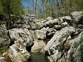
 Ghost Dance Canyon, Dixon Springs State Park, April 2014 | |
Map of the U.S. state of Illinois showing the location of Dixon Springs State Park | |
| Location | Pope County, Illinois, United States |
| Nearest city | Golconda, Illinois |
| Coordinates | 37°22′57″N 88°39′56″W / 37.38250°N 88.66556°W |
| Area | 801 acres (324 ha) |
| Established | 1946 |
| Governing body | Illinois Department of Natural Resources |
Dixon Springs State Park is an Illinois state park in Pope County, Illinois, United States, and is one of several state parks in the Illinois Shawnee Hills. The park is on a giant block of rock which was dropped 200 feet (61 m) along a fault that extends northwesterly across Pope County. The 801-acre (324 ha) park is about 10 miles (16 km) west of Golconda on Illinois Route 146, near its junction with Illinois Route 145. The first land acquisition was in 1946.

