Dniprovskyi District
Дніпровський район | |
|---|---|
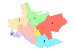
 Administrative map of Zaporizhzhia; the Dniprovskyi District is indicated by the number 4. | |
| Coordinates: 47°52′44″N 35°03′50″E / 47.87889°N 35.06389°E | |
| Country | |
| Municipality | Zaporizhzhia Municipality |
| Established | 16 March 1928 |
| Area | |
| • Total | 49.7 km2 (19.2 sq mi) |
| Population (2001) | |
| • Total | 151,900 |
| • Density | 3,100/km2 (7,900/sq mi) |
| Time zone | UTC+2 (EET) |
| • Summer (DST) | UTC+3 (EEST) |
The Dniprovskyi District (Ukrainian: Дніпровський район, Dniprovsʹkyi raion) is one of seven administrative urban districts (raions) of the city of Zaporizhzhia, located in southern Ukraine.[1][2] Its population was 151,900 in the 2001 Ukrainian Census.[3]
- ^ "Number of the population of the City of Zaporizhzhia" (PDF) (in Ukrainian). State Statistics Service of Ukraine in Zaporizhzhia Oblast. 20 June 2012. Retrieved 25 January 2015.
- ^ "City Districts - Zaporizhzhia City Council". zp.gov.ua. Retrieved 16 September 2023.
- ^ "About number and composition population of Zaporizhzhia Region by data All-Ukrainian census of the population 2001". 2001.ukrcensus.gov.ua. Retrieved 16 September 2023.
