Dolores, Colorado | |
|---|---|
 Aerial photo of Dolores | |
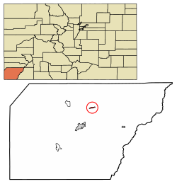
 Location of the Town of Dolores in Montezuma County, Colorado. | |
Location of the Town of Dolores in the United States. | |
| Coordinates: 37°28′24″N 108°30′14″W / 37.47333°N 108.50389°W[2] | |
| Country | |
| State | |
| County | Montezuma County[1] |
| Incorporated | July 19, 1900[3] |
| Government | |
| • Type | Statutory Town[1] |
| Area | |
| • Total | 0.664 sq mi (1.721 km2) |
| • Land | 0.664 sq mi (1.721 km2) |
| • Water | 0.000 sq mi (0.000 km2) |
| Elevation | 6,946 ft (2,117 m) |
| Population | |
| • Total | 885 |
| • Density | 1,332/sq mi (514/km2) |
| Time zone | UTC−07:00 (MST) |
| • Summer (DST) | UTC−06:00 (MDT) |
| ZIP code[6] | 81323 |
| Area code | 970 |
| FIPS code | 08-20770 |
| GNIS feature ID | 2412439[5] |
| Website | townofdolores |
Dolores is a Statutory Town located in Montezuma County, Colorado, United States.[1] The town population was 885 at the 2020 United States Census.[4]
- ^ a b c d "Active Colorado Municipalities". Colorado Department of Local Affairs. Retrieved October 16, 2021.
- ^ "2014 U.S. Gazetteer Files: Places". United States Census Bureau. July 1, 2014. Retrieved January 5, 2015.
- ^ "Colorado Municipal Incorporations". State of Colorado, Department of Personnel & Administration, Colorado State Archives. December 1, 2004. Retrieved September 2, 2007.
- ^ a b c "Decennial Census P.L. 94-171 Redistricting Data". United States Census Bureau, United States Department of Commerce. August 12, 2021. Retrieved September 7, 2021.
- ^ a b U.S. Geological Survey Geographic Names Information System: Dolores, Colorado
- ^ "ZIP Code Lookup". United States Postal Service. Archived from the original (JavaScript/HTML) on November 4, 2010. Retrieved September 8, 2007.
