Don Sak
ดอนสัก | |
|---|---|
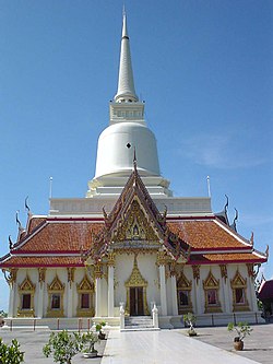
 Wat Khao Suwan Pradit | |
 District location in Surat Thani province | |
| Coordinates: 9°18′50″N 99°41′25″E / 9.31389°N 99.69028°E | |
| Country | Thailand |
| Province | Surat Thani |
| Seat | Don Sak |
| Area | |
• Total | 460.9 km2 (178.0 sq mi) |
| Population (2005) | |
• Total | 35,468 |
| • Density | 77.0/km2 (199/sq mi) |
| Time zone | UTC+7 (ICT) |
| Postal code | 84220 |
| Geocode | 8403 |
Don Sak (Thai: ดอนสัก, pronounced [dɔ̄ːn sàk]) is a district (amphoe) in eastern Surat Thani province. The two principal ferry companies offering service to Samui Island leave from piers in the district.
Neighboring districts are (from the east clockwise): Khanom and Sichon, Nakhon Si Thammarat province); and Kanchanadit of Surat Thani. To the north is the Gulf of Thailand, with islands encompassed by the Ko Samui District.