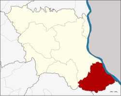
Don Tan
ดอนตาล | |
|---|---|
 Phu Sa Dok Bua National Park, a national park in the district | |
 District location in Mukdahan province | |
| Coordinates: 16°19′0″N 104°55′12″E / 16.31667°N 104.92000°E | |
| Country | |
| Province | Mukdahan |
| Seat | Don Tan |
| District established | 1963 |
| Area | |
• Total | 510.92 km2 (197.27 sq mi) |
| Population (2008) | |
• Total | 42,215 |
| • Density | 81.3/km2 (211/sq mi) |
| Time zone | UTC+7 (ICT) |
| Postal code | 49120 |
| Geocode | 4903 |
Don Tan (Thai: ดอนตาล, pronounced [dɔ̄ːn tāːn]) is the southeasternmost district (amphoe) of Mukdahan province, northeastern Thailand.