Dongan Hills | |
|---|---|
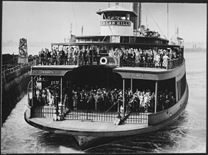
 Ferryboat Dongan Hills of the Staten Island Ferry, seen approaching a landing in 1945 | |
 Location in New York City | |
| Coordinates: 40°35′20″N 74°05′46″W / 40.589°N 74.096°W | |
| Country | |
| State | |
| City | |
| Borough | |
| Community District | Staten Island 2[1] |
| Area | |
| • Total | 3.65 km2 (1.409 sq mi) |
| Population (2011)[2] | |
| • Total | 16,375 |
| • Density | 4,500/km2 (12,000/sq mi) |
| Economics | |
| • Median income | $73,378 |
| ZIP Codes | 10304, 10305 |
| Area code | 718, 347, 929, and 917 |
Dongan Hills is a neighborhood located within the New York City borough of Staten Island. It is on the island's East Shore. Dongan Hills is bounded by Laconia Avenue to the southeast, Jefferson Avenue on the southwest, Richmond Road on the northwest, and Old Town Road to the north. It is adjacent to New Dorp and Grant City to the southwest, Todt Hill to the northwest, Old Town/Concord to the northeast, and South Beach and Midland Beach to the southeast.
Dongan Hills is part of Staten Island Community District 2 and its ZIP Codes are 10304 and 10305.[1] Dongan Hills is patrolled by the 122nd Precinct of the New York City Police Department.
- ^ a b "NYC Planning | Community Profiles". communityprofiles.planning.nyc.gov. New York City Department of City Planning. Retrieved March 18, 2019.
- ^ a b c "Dongan Hills neighborhood in New York". Retrieved March 18, 2019.