Dongen | |
|---|---|
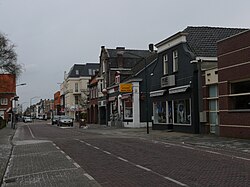
 Street through Dongen | |
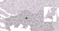
 Location in North Brabant | |
| Coordinates: 51°38′N 4°56′E / 51.633°N 4.933°E | |
| Country | Netherlands |
| Province | North Brabant |
| Government | |
| • Body | Municipal council |
| • Mayor | Marina Starmans-Gelijns (VVD) |
| Area | |
| • Total | 29.74 km2 (11.48 sq mi) |
| • Land | 29.24 km2 (11.29 sq mi) |
| • Water | 0.50 km2 (0.19 sq mi) |
| Elevation | 4 m (13 ft) |
| Population (January 2021)[4] | |
| • Total | 26,368 |
| • Density | 902/km2 (2,340/sq mi) |
| Demonym | Dongenaar |
| Time zone | UTC+1 (CET) |
| • Summer (DST) | UTC+2 (CEST) |
| Postcode | 5100–5109 |
| Area code | 0162 |
| Website | www |
Dongen (Dutch pronunciation: [ˈdɔŋə(n)] ) is a municipality and village in North Brabant, in the southern Netherlands. In the past it had a profitable leather industry, and a few old shoe factories in the town's older sections remain. The town is near a small river called the Donge, the water of which was used extensively for the leather industry. The Aerts automobile was built here in 1899.
- ^ "Burgemeester René (M.F.A.) van Diessen" (in Dutch). Gemeente Dongen. Archived from the original on 12 May 2014. Retrieved 10 May 2014.
- ^ "Kerncijfers wijken en buurten 2020" [Key figures for neighbourhoods 2020]. StatLine (in Dutch). CBS. 24 July 2020. Retrieved 19 September 2020.
- ^ "Postcodetool for 5104JJ". Actueel Hoogtebestand Nederland (in Dutch). Het Waterschapshuis. Retrieved 10 May 2014.
- ^ "Bevolkingsontwikkeling; regio per maand" [Population growth; regions per month]. CBS Statline (in Dutch). CBS. 1 January 2021. Retrieved 2 January 2022.

