Doodhpathri | |
|---|---|
Hill Station | |
| DoodhPathri Development Authority | |

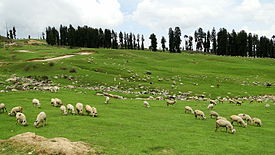
 Nature, scenery of Doodhpathri | |
| Nickname: Valley Of Milk | |
| Motto(s): We Serve, We Invite You To Visit Us | |
| Coordinates: 33°51′N 74°34′E / 33.85°N 74.56°E | |
| Country | |
| Region | Jammu and Kashmir |
| District | Budgam |
| Named for | White Appearance Of Water |
| Government | |
| • Body | Doodhpathri Development Authority |
| Elevation | 2,730 m (8,960 ft) |
| Languages | |
| • Official | Kashmiri, Urdu, Hindi, Dogri, English[1][2] |
| Languages | |
| • Local | Kashmiri, Gujari, Pahadi |
| Time zone | UTC+5:30 (IST) |
| Pin Code | 191111 |
| Vehicle registration | JK04 |
Doodhpathri (transl. Valley of Milk; Urdu pronunciation: [d̪uːd̪ʱ pət̪ʰɾiː]; Kashmiri pronunciation: [dɔdɨ patʰɨr]) is a tourist destination and a hill station located in the Khansahib tehsil of the Budgam district of Jammu and Kashmir, India.[3][4] Situated at an altitude of 2,730 metres (8,960 ft) from sea level, it is located at a distance of 42 km (26 mi) from Jammu and Kashmir's summer capital, Srinagar, and 30 km (19 mi) from its district headquarters, Budgam.
- ^ "The Jammu and Kashmir Official Languages Act, 2020" (PDF). The Gazette of India. 27 September 2020. Retrieved 27 September 2020.
- ^ "Parliament passes JK Official Languages Bill, 2020". Rising Kashmir. 23 September 2020. Archived from the original on 24 September 2020. Retrieved 30 May 2021.
- ^ "Doodhpatri: A new travel destination in Kashmir". 16 September 2022.
- ^ ":: District Budgam (Official website)". budgam.nic.in. Retrieved 13 October 2015.

