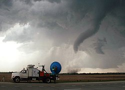


Doppler on Wheels (or DOW) is a fleet of X-band and C-band mobile and quickly-deployable truck-borne radars which are the core instrumentation of the Flexible Array of Radars and Mesonets[1] affiliated with the University of Alabama Huntsville[2] and led by Joshua Wurman, with the funding partially provided by the National Science Foundation (NSF), as part of the "Community Instruments and Facilities," (CIF) program. The DOW fleet and its associated Mobile Mesonets and deployable weather stations (PODs & Polenet) have been used throughout the United States since 1995, as well as occasionally in Europe and Southern America.[1] The Doppler on Wheels network has deployed itself through hazardous and challenging weather to gather data and information that may be missed by conventional stationary radar systems.
- ^ a b "FARM: The DOW Network". farm.atmos.illinois.edu. Retrieved 25 April 2024.
- ^ "News | College of Science | UAH becomes the largest mobile radar facility in the U.S. with the addition of the FARM to its deployable weather research fleet - UAH | The University of Alabama in Huntsville". www.uah.edu.