Dorchester | |
|---|---|
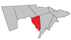
 Location within Westmorland County, New Brunswick. | |
| Coordinates: 46°11′N 64°36′W / 46.19°N 64.60°W | |
| Country | |
| Province | |
| County | Westmorland County |
| Erected | 1787 |
| Area | |
| • Land | 90.13 km2 (34.80 sq mi) |
| Population (2021)[1] | |
• Total | 438 |
| • Density | 4.9/km2 (13/sq mi) |
| • Change 2016-2021 | |
| • Dwellings | 207 |
| Time zone | UTC-4 (AST) |
| • Summer (DST) | UTC-3 (ADT) |
| Figures do not include portions within the city of Dieppe, the villages of Dorchester and Memramcook, and the Fort Folly 1 Indian reserve | |
Dorchester is a geographic parish in Westmorland County, New Brunswick, Canada.[4]
For governance purposes it is divided between the city of Dieppe, the town of Tantramar, the incorporated rural community of Strait Shores,[5] the Fort Folly 1 Indian reserve, and the Southeast rural district.[6] With exception of the Indian reserve, all are members of the Southeast Regional Service Commission.[7]
Prior to the 2023 governance reform, the parish was divided between the villages of Dorchester and Memramcook;[8] the Indian reserve; and the local service district of the parish of Dorchester, which further included the special services area of Calhoun Road.[9]
- ^ a b "Census Profile". Statistics Canada. 26 October 2022. Retrieved 29 October 2022.
- ^ "Chapter T-3 Territorial Division Act". Government of New Brunswick. Retrieved 26 March 2023.
- ^ "Chapter I-13 Interpretation Act". Government of New Brunswick. Retrieved 26 March 2023.
- ^ The Territorial Division Act[2] divides the province into 152 parishes, the cities of Saint John and Fredericton, and one town of Grand Falls. The Interpretation Act[3] clarifies that parishes include any local government within their borders.
- ^ "Southeast Regional Service Commission: RSC 7". Government of New Brunswick. Retrieved 26 March 2023.
- ^ "Southeast Regional Service Commission: RD 7". Government of New Brunswick. Retrieved 26 March 2023.
- ^ "Regions Regulation – Regional Service Delivery Act". Government of New Brunswick. 21 July 2022. Retrieved 26 March 2023.
- ^ "New Brunswick Regulation 85-6 under the Municipalities Act (O.C. 85-45)". Government of New Brunswick. Retrieved 23 July 2020.
- ^ "Local Service Districts Regulation - Municipalities Act". Government of New Brunswick. 25 June 2021. Retrieved 26 March 2023.