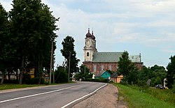
Dotnuva | |
|---|---|
Town | |
 Dotnuva church | |
| Coordinates: 55°21′0″N 23°54′0″E / 55.35000°N 23.90000°E | |
| Country | |
| Ethnographic region | Samogitia |
| County | |
| Municipality | Kėdainiai district municipality |
| Eldership | Dotnuva Eldership |
| Capital of | Dotnuva eldership |
| First mentioned | 1372 [1] |
| Population (2021) | |
| • Total | 643 |
| Time zone | UTC+2 (EET) |
| • Summer (DST) | UTC+3 (EEST) |
Dotnuva (formerly Polish: Datnów, Russian: Датновъ, Датново, Датнов, German: Dotnau) is a small town with a 2003 population of 775 in central Lithuania, 10 km northwest of Kėdainiai, in the Kėdainiai district municipality. It is located on the Dotnuvėlė River. The geographical center of Lithuania, in the village of Ruoščiai, is only a few kilometers away. There is a Catholic church, former Bernardine monastery, an abandoned sawmill and watermill in Dotnuva. The Dotnuva manor is in the nearby town of Akademija.
Dotnuva is an important center of agriculture.
- ^ "Akademija, žemdirbių Lietuvos sostinė". Veidas. 7 May 2016.


