Douarnenez | |
|---|---|
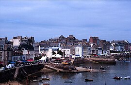
 Seafront of Douarnenez | |
| Coordinates: 48°05′34″N 4°19′45″W / 48.0928°N 4.3292°W | |
| Country | France |
| Region | Brittany |
| Department | Finistère |
| Arrondissement | Quimper |
| Canton | Douarnenez |
| Intercommunality | Douarnenez Communauté |
| Government | |
| • Mayor (2020–2026) | Jocelyne Poitevin[1] |
Area 1 | 24.94 km2 (9.63 sq mi) |
| Population (2021)[2] | 14,163 |
| • Density | 570/km2 (1,500/sq mi) |
| Time zone | UTC+01:00 (CET) |
| • Summer (DST) | UTC+02:00 (CEST) |
| INSEE/Postal code | 29046 /29100 |
| Elevation | 0–85 m (0–279 ft) |
| 1 French Land Register data, which excludes lakes, ponds, glaciers > 1 km2 (0.386 sq mi or 247 acres) and river estuaries. | |
Douarnenez (Breton pronunciation: [duarˈnẽːnɛs], French: [dwaʁnəne]; meaning douar (land) an enez (the island) or land of the island), is a commune in the French department of Finistère, region of Brittany, northwestern France.
It is located at the mouth of the Pouldavid River, an estuary on the southern shore of Douarnenez Bay in the Atlantic Ocean, 25 kilometres (16 mi) north-west of Quimper.[3] The population in 2008 was 15,066. It has declined since the mid-20th century because of jobs lost from declines in the fishing industry. But it still has fish canning facilities (sardines and mackerel) although sardine fishing, for which the town became famous, has fallen off in recent years.
Douarnenez has a growing tourist industry, with numerous visitors attracted annually to its pleasant location and warm climate, and also because of its marinas, maritime museum, regattas and sandy beaches. The island of Tristan off Douarnenez can be reached by foot at low tide. It is linked to the legend of Tristan and Iseult from the times of King Arthur.
- ^ "Répertoire national des élus: les maires". data.gouv.fr, Plateforme ouverte des données publiques françaises (in French). 2 December 2020.
- ^ "Populations légales 2021" (in French). The National Institute of Statistics and Economic Studies. 28 December 2023.
- ^ "Google Maps". Retrieved 26 May 2016.


