Douglas County | |
|---|---|
 One of two county buildings for Douglas County in Castle Rock | |
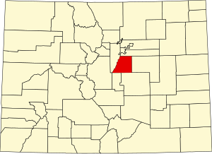
 Location within the U.S. state of Colorado | |
 Colorado's location within the U.S. | |
| Coordinates: 39°21′N 104°56′W / 39.35°N 104.93°W | |
| Country | |
| State | |
| Founded | November 1, 1861 |
| Named for | Stephen A. Douglas |
| Seat | Castle Rock |
| Largest community | Highlands Ranch |
| Area | |
• Total | 843 sq mi (2,180 km2) |
| • Land | 840 sq mi (2,200 km2) |
| • Water | 2.6 sq mi (7 km2) 0.3% |
| Population (2020) | |
• Total | 357,978 |
• Estimate (2023)[1] | 383,906 |
| • Density | 426/sq mi (164/km2) |
| Time zone | UTC−7 (Mountain) |
| • Summer (DST) | UTC−6 (MDT) |
| Congressional districts | 4th, 6th |
| Website | www |


Douglas County is a county located in the U.S. state of Colorado. As of the 2020 Census, the population was 357,978. The county is named in honor of U.S. Senator Stephen A. Douglas.[2] The county seat is Castle Rock.[3]
Douglas County is part of the Denver–Aurora–Lakewood metropolitan statistical area. It is located midway between Colorado's two largest cities, Denver and Colorado Springs, and contains a portion of Aurora, the state's third-largest city. Douglas County has the highest median household income of any Colorado county or statistical equivalent. It is ranked seventh nationally in that category.
- ^ "Annual Estimates of the Resident Population for Counties: April 1, 2020 to July 1, 2023". United States Census Bureau. Retrieved March 24, 2024.
- ^ "State & County QuickFacts". United States Census Bureau. Retrieved September 5, 2021.
- ^ "Find a County". National Association of Counties. Archived from the original on May 31, 2011. Retrieved June 7, 2011.

