Douglas County | |
|---|---|
 Douglas County Courthouse in Roseburg | |
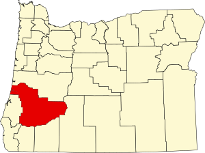
 Location within the U.S. state of Oregon | |
 Oregon's location within the U.S. | |
| Coordinates: 43°17′N 123°11′W / 43.29°N 123.18°W | |
| Country | |
| State | |
| Founded | January 7, 1852 |
| Named for | Stephen A. Douglas |
| Seat | Roseburg |
| Largest city | Roseburg |
| Area | |
• Total | 5,134 sq mi (13,300 km2) |
| • Land | 5,036 sq mi (13,040 km2) |
| • Water | 98 sq mi (250 km2) 1.9% |
| Population (2020) | |
• Total | 111,201 |
• Estimate (2023) | 112,435 |
| • Density | 21/sq mi (8/km2) |
| Time zone | UTC−8 (Pacific) |
| • Summer (DST) | UTC−7 (PDT) |
| Congressional districts | 2nd, 4th |
| Website | douglascountyor |


Douglas County is one of the 36 counties in the U.S. state of Oregon. As of the 2020 census, the population was 111,201.[1] The county seat is Roseburg.[2] The county is named after Stephen A. Douglas, an American politician who supported Oregon statehood. Douglas County comprises the Roseburg, OR Micropolitan Statistical Area. In regards to area, Douglas County is the largest county west of the Oregon Cascades.
- ^ "State & County QuickFacts". United States Census Bureau. Retrieved May 15, 2023.
- ^ "Find a County". National Association of Counties. Archived from the original on May 31, 2011. Retrieved June 7, 2011.