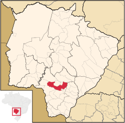
Dourados | |
|---|---|
| Municipality of Dourados | |
 | |
| Nicknames: Model City Mercosul Portal | |
| Motto: Terra de Antônio João | |
 Location in Mato Grosso do Sul | |
| Coordinates: 22°13′15″S 54°48′21″W / 22.22083°S 54.80583°W | |
| Country | |
| State | |
| Founded | 1935 |
| Government | |
| • Mayor | Alan Guedes (DEM) |
| Area | |
| 4,086.4 km2 (1,578.4 sq mi) | |
| • Land | 4,086.4 km2 (1,578.4 sq mi) |
| • Urban | 205.990 km2 (79.533 sq mi) |
| Elevation | 430 m (1,410 ft) |
| Population (2022)[1] | |
| 243,367 | |
| • Density | 60/km2 (150/sq mi) |
| Time zone | UTC−4 (AMT) |
| HDI (2010) | 0.747 – high[2] |
| Website | www |
Dourados is a Brazilian municipality, situated in the state of Mato Grosso do Sul, 225 km (140 mi) Southwest of Campo Grande (the state's capital). It has a population of about 225,000 inhabitants, and its economy is based mainly in arable agriculture (particularly Soya, Maize and Sugar Cane) and in cattle ranching. Dourados is also the second most populous and important city of this state.
Its media, commerce, and services more than take care of the thirty cities of Mato Grosso do Sul, including a part of Paraguay. For its size and importance, it is an economic and social capital of a region that possesses approximately a million inhabitants (Vestibule of the Mercosul – the Common Market of the South).
Its development was slow until the first half of the 20th century, because of transportation limitations (highways and roads), especially with Campo Grande and the State of São Paulo. From 1950, it increased its development with the construction of roads. With this, it received migrants from other parts of the country (especially Sulistas and São Paulo) and immigrants (mainly Japanese). The city has a close relationship with Paraguay its next door neighbor, which is 120 km (75 mi) away. This is a strong factor in the ethnic and cultural union between the city and the neighboring country. This explains why 30% of the inhabitants of Dourados have some Paraguayan family link.
- ^ IBGE 2022
- ^ "Archived copy" (PDF). United Nations Development Programme (UNDP). Archived from the original (PDF) on 8 July 2014. Retrieved 1 August 2013.
{{cite web}}: CS1 maint: archived copy as title (link)


