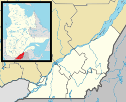
l'Île Dowker | |
|---|---|
| Geography | |
| Location | Saint Lawrence River |
| Coordinates | 45°24′10″N 73°53′40″W / 45.40278°N 73.89444°W |
| Archipelago | Hochelaga Archipelago |
| Area | 1 km2 (0.39 sq mi) |
| Length | 1 km (0.6 mi) |
| Width | 1 km (0.6 mi) |
| Administration | |
Canada | |
| Province | Quebec |
| City | Notre-Dame-de-l'Île-Perrot |
Dowker Island is an uninhabited island in Lake Saint Louis, a widening of the Saint Lawrence River south of Montreal Island, Quebec. It is in the municipality of Notre-Dame-de-l'Île-Perrot[1] which intends to preserve its natural state.[2]
The island is about a kilometre in length and breadth. Its surface geology is undifferentiated till deposits.[3] It is low-lying, mostly in a 100-year flood area,[4] and contains a muskrat habitat.[5]
- ^ "Electoral Map" (PDF). Notre-Dame-de-l'Île-Perrot. Retrieved 3 June 2018.
- ^ PROJET DE RÈGLEMENT NUMÉRO 436-8. La Ville de Notre-Dame-de-l'Île-Perrot. 2016.
- ^ "Montreal Island Map 1426A". Geological Survey of Canada. Retrieved 3 June 2018.
- ^ Plan_zonage + annexes 14-15-19 (PDF). Notre-dame-de-l'île-perrot. Retrieved 3 June 2018.
- ^ Règlements d'amendement du plan d'urbanisme (PDF). Notre-Dame-de-l'Île-Perrot. 2006. p. 105. Retrieved 3 June 2018.
