This article has multiple issues. Please help improve it or discuss these issues on the talk page. (Learn how and when to remove these messages)
|
| Doyle Peak | |
|---|---|
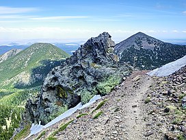
 Doyle Peak (left, flat top) and Fremont Peak from the east side of Agassiz Peak. | |
| Highest point | |
| Elevation | 11,464 ft (3,494 m) NAVD 88[1] |
| Prominence | 660 ft (201 m)[1] |
| Parent peak | Fremont Peak |
| Coordinates | 35°19′48″N 111°38′47″W / 35.3300087°N 111.6462717°W[2] |
| Geography | |
| Location | Coconino County, Arizona, U.S. |
| Parent range | San Francisco Peaks |
| Topo map | USGS Humphreys Peak |
| Climbing | |
| Easiest route | Off trail hike |

Doyle Peak is a peak in the Coconino National Forest, and the fourth-highest peak in the San Francisco Peaks of northern Arizona. It is the sixth-highest named point in the state of Arizona, with an elevation of 11,464 feet (3,494 m).
- ^ a b "Doyle Peak, Arizona". Peakbagger.com. Retrieved 2009-01-06.
- ^ "Doyle Peak". Geographic Names Information System. United States Geological Survey, United States Department of the Interior. Retrieved 2009-01-06.
