Dresbach | |
|---|---|
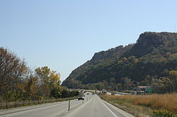
 Dresbach along Interstate 90 looking south | |
| Coordinates: 43°53′22″N 91°20′38″W / 43.88944°N 91.34389°W | |
| Country | United States |
| State | Minnesota |
| County | Winona County |
| Township | Dresbach Township |
| Area | |
| • Total | 1.09 sq mi (2.82 km2) |
| • Land | 0.94 sq mi (2.45 km2) |
| • Water | 0.14 sq mi (0.38 km2) |
| Elevation | 866 ft (264 m) |
| Population (2020) | |
| • Total | 272 |
| • Density | 287.83/sq mi (111.12/km2) |
| Time zone | UTC-6 (Central (CST)) |
| • Summer (DST) | UTC-5 (CDT) |
| ZIP code | 55947 and 55925 |
| Area code | 507 |
| GNIS feature ID | 2806365[1] |
Dresbach (/ˈdʒrɛsbɑːk/ DRESS-bahk)[3] is an unincorporated community in Dresbach Township, Winona County, Minnesota, United States.
The community is located on the west side of the Mississippi River along Interstate 90 between Winona and La Crosse. U.S. Highways 61 and 14 are briefly co-signed with Interstate 90 at this point.
Dresbach is located along the Mississippi River. Nearby places include Winona, Dakota, Nodine, La Crescent, La Crosse, Onalaska, and Great River Bluffs State Park. Local businesses include the Dresbach travel information center, and Lock and Dam No. 7 on the Mississippi River.
- ^ a b c U.S. Geological Survey Geographic Names Information System: Dresbach, Minnesota
- ^ "2020 U.S. Gazetteer Files". United States Census Bureau. Retrieved July 24, 2022.
- ^ "Minnesota Pronunciation Guide". Associated Press. Archived from the original on July 22, 2011. Retrieved July 4, 2011.


