Dromara
| |
|---|---|
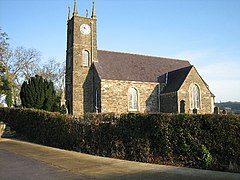
 St John's Church, Dromara | |
Location within County Down | |
| Population | 1,006 (2011 census) |
| Irish grid reference | J287497 |
| • Belfast | 20 mi (32 km) |
| District | |
| County | |
| Country | Northern Ireland |
| Sovereign state | United Kingdom |
| Post town | DROMORE |
| Postcode district | BT25 |
| Dialling code | 028, +44 28 |
| UK Parliament | |
| NI Assembly | |
Dromara (from Irish Droim mBearach, meaning 'ridge of heifers')[1] is a village, townland (of 242 acres) and civil parish in County Down, Northern Ireland. It lies 10 kilometres (6.2 mi) to the southwest of Ballynahinch on the northern slopes of Slieve Croob, with the River Lagan flowing through it. It is situated in Dromara (civil parish) and the historic barony of Iveagh Lower, Lower Half.[2] In the 2011 census it had a population of 1,006 people.[3]
- ^ Placenames NI Archived 31 March 2012 at the Wayback Machine
- ^ "Dromara". IreAtlas Townlands Database. Retrieved 19 May 2015.
- ^ "Census 2011 Population Statistics for Dromara Settlement". Northern Ireland Statistics and Research Agency (NISRA). Retrieved 23 April 2021.
 This article contains quotations from this source, which is available under the Open Government Licence v3.0. © Crown copyright.
