| Dubai Creek Khūr Dubay | |
|---|---|
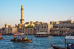
 Abras (water taxis) on Dubai Creek | |
| Details | |
| Location | Dubai, United Arab Emirates |
| Length | Total 24 kilometres (15 mi) of which natural length is 14 kilometres (8.7 mi) |
| North end | Al Shindagha area |
| South end | Jumeirah Beach, Jumeirah area |
Dubai Creek (Arabic: خور دبي, romanized: Khūr Dubay) has been described as a natural saltwater creek, tidal inlet, and watercourse or waterway in Dubai, United Arab Emirates (UAE). It extends about 9 miles (14 km) inwards and forms a natural port that has traditionally been used for trade and transport.[1] The creek ranges from 200 to 1,200 metres (660 to 3,940 ft) in width while the average depth is about 6.5 to 7 metres (21 to 23 ft). Previously, it extended to Ras Al Khor Wildlife Sanctuary but as part of the new Business Bay Canal and Dubai Canal, it extends a further 13 km (8.1 mi)[2] to the Persian Gulf.[3]
In the 1950s, extensive development of the creek began, including dredging and construction of breakwaters. A number of bridges allow movement of vehicles across the creek while abras are used as taxis. The banks and route alongside the creek houses notable government, business and residential areas. A number of tourist locations and hotels are situated along the creek. The Dubai Creek, a vital waterway in the heart of the city, plays a significant role in Dubai's growth by handling the passage of more than 13,000 ships annually. As a major artery for maritime trade, it supports the city's commercial operations. Enhancements to the Creek's infrastructure are being made through a project aimed at improving safety and security measures for maritime traffic and commercial activities. These improvements are expected to strengthen the city's role as a regional hub for trade and ensure smoother, more secure operations for the numerous ships passing through each year.[4]
- ^ Gupte 2011, p. 76.
- ^ Hammad 2019, p. 101–102.
- ^ Karanam, Sankarbabu; Juma, Ibrahim Mohammad; AlHarmoudi, Alya Abdulrahim; Yang, Zongyan (30 December 2018). "Hydrodynamics of Extended Dubai Creek System". Coastal Engineering Proceedings (36). Proceedings of 36th Conference on Coastal Engineering, Baltimore, Maryland, 2018: 25. doi:10.9753/icce.v36.currents.25. S2CID 188648755. Retrieved 10 October 2021.
- ^ Abdulla, Nasreen. "Dubai announces Dh112 million Creek restoration project to prevent potential flooding". Khaleej Times. Retrieved 23 October 2024.